Pilt:Non-Native American Nations Control over South America 1700 and on.gif

Algteedüstü (800 × 1100 pikslit, 262 KB, MIME-tüüp: image/gif, korduv, 43 kaadrit, 2 min 2 s)
| Seletüs | Non-Native American Nations Control over South America — 1700 and on | ||
| Kuupäiv | |||
| Läteq | Üleslaatja uma tüü | ||
| Tegijä | Esemono | ||
| Luba (Faili vahtsõst pruukminõ) |
|
||
| Teised versioonid | Derivative works of this file: Non-Native American Nations Control over South America 1700 and on.ogv |
| Former nations of South America | |||
|---|---|---|---|
| Entre Ríos | |||
| Juliana Republic | |||
| Gran Colombia | |||
| Liga Federal | |||
| Riograndense Republic | |||
| Colonial Brazil; United Kingdom of Portugal, Brazil and the Algarves | |||
| Viceroyalty of Peru, Viceroyalty of New Granada | |||
| Present day nations of South America | |||
| Argentina | |||
| Bolivia | |||
| Brazil | |||
| Chile | |||
| Colombia | |||
| Ecuador | |||
| French Guiana (France) | |||
| Netherlands | |||
| Guyana | |||
| Paraguay | |||
| Peru | |||
| Suriname | |||
| United Kingdom | |||
| Uruguay | |||
| Venezuela | |||
| *Flags used are flags of present day countries or the last flag used by a now-defunct nation. | |||
Special:MyLanguage/Special:MyLanguage/Special:MyLanguage/== Notes ==
- Islands close to South America aren't included as this is a map about continental South America.
- Not all borders are to scale with some being changed to be easier to see.
- When a political change is too small to notice a small note is added to help point to the change.
- When referring to countries the most common or modern name is used—i.e. England instead of the United Kingdom.
- After the 1940s Ecuadorian-Peruvian war a new border was demarcated between Ecuador and Peru. However between 1943 and 1946, the United States Air Force performed several aerial reconnaissance missions over the Cordillera del Cóndor region (losing 2 aircraft and 14 men in accidents) to help in the demarcation efforts. They found that the Cenepa river was much longer than previously thought and that it runs between the Zamora and the Santiago. This finding conflicted with article VIII, point B-1 of the Rio Protocol, which laid out delineation of the border for that area as follows:
- From the Quebrada de San Francisco, the watershed between the Zamora and Santiago Rivers, to the confluence of the Santiago River with the Yaupi;
- article VIII, point B-1 of the Rio Protocol
The difficulty was that there is not one watershed between the Zamora and the Santiago, but two, as interpreted by Ecuador. This resulted in Ecuadorian president Galo Plaza halting demarcation in 1949. About 78 kilometers of border were left unmarked. These 78 km are still in dispute but are too small to be shown on the map. Las islas cercanas a América del Sur no están incluidas ya que este es un mapa sobre América del Sur continental.
- No todos los bordes están a escala y algunos se han cambiado para que sean más fáciles de ver.
- Cuando un cambio político es demasiado pequeño para notarlo, se agrega una pequeña nota para ayudar a señalar el cambio.
- Cuando se hace referencia a países, se utiliza el nombre más común o moderno, es decir, Inglaterra en lugar del Reino Unido.
- Después de la Guerra ecuatoriano-peruana de la década de 1940 se demarcó una nueva frontera entre Ecuador y Perú. Sin embargo, entre 1943 y 1946, la Fuerza Aérea de los Estados Unidos realizó varias misiones de reconocimiento aéreo sobre la región de la Cordillera del Cóndor (perdiendo 2 aviones y 14 hombres en accidentes) para ayudar en los esfuerzos de demarcación. Descubrieron que el río Cenepa era mucho más largo de lo que se pensaba y que corre entre el Zamora y el Santiago. Este hallazgo estaba en conflicto con el artículo VIII, punto B-1 del Protocolo de Río, que establecía la delimitación de la frontera para esa zona de la siguiente manera:
- Desde la Quebrada de San Francisco, divisoria de aguas entre los ríos Zamora y Santiago, hasta la confluencia del río Santiago con el Yaupi;
- artículo VIII, punto B-1 del Protocolo de Río
La dificultad era que entre el Zamora y el Santiago no hay una divisoria de aguas, sino dos, según la interpretación de Ecuador. Esto dio lugar a que el presidente ecuatoriano, Galo Plaza, detuviera la demarcación en 1949. 'Cerca de 78 kilómetros de frontera quedaron sin marcar. Estos 78 km aún están en disputa, pero son demasiado pequeños para mostrarlos en el mapa.
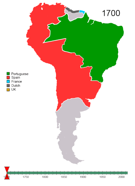
=== portugués Durante los dos primeros siglos del período colonial, atraídas por los vastos recursos naturales y la tierra sin explotar, otras potencias europeas intentaron establecer colonias en varias partes del territorio brasileño, desafiando la bula papal y el Tratado de Tordesillas, que había dividido el Nuevo Mundo en dos partes entre Portugal y España. El Brasil colonial era portugués. Los colonos franceses intentaron establecerse en la actual Río de Janeiro, de 1555 a 1567 (el llamado episodio France Antarctique), y en la actual São Luís, de 1612 a 1614 (la llamada France Equinoxiale). Después de varios años de guerra abierta, los holandeses se retiraron formalmente en 1661. De estos intentos fallidos quedaron pocas influencias culturales y étnicas francesas y holandesas.
inglés El Nuevo Reino de Granada ( español : Nuevo Reino de Granada ) fue el nombre que se le dio a un grupo de provincias coloniales españolas del siglo XVI en el norte de América del Sur, correspondiente principalmente a la actual Colombia . Pasó a formar parte del Virreinato de la Nueva Granada en 1717. El virreinato del Perú gobernó la parte sur del imperio español.
Holandés En el Tratado de Breda, en 1667, los holandeses decidieron mantener la naciente colonia de plantaciones de Surinam conquistada a los británicos, mientras dejaban el pequeño puesto comercial de Nueva Ámsterdam en América del Norte, ahora la ciudad de Nueva York, en manos de los británicos.
Guyana Lord Willoughby, famoso en la historia temprana de Barbados, también centró su atención en Guyana y fundó un asentamiento en Surinam en 1651. Esta fue capturada por los holandeses en 1667 y, aunque luego fue recuperada por los británicos, fue cedida a los Holandés en la Paz de Breda (1667).
Francés (Français)
En 1667, los británicos tomaron Guayana Francesa. Después del Tratado de Breda el 31 de julio de 1667, el área fue devuelta a la gente de Francia. Los holandeses la ocuparon brevemente durante un período en 1676, aunque ocuparon Cayena entre 1664 y 1676.
Mapuche
Los Mapuche resistieron con éxito muchos intentos del Imperio Inca para subyugarlos, a pesar de su falta de organización estatal. Lucharon contra el Sapa Inca Tupac Yupanqui y su ejército. El resultado del cruento enfrentamiento de tres días conocido como la Batalla del Maule fue que la conquista inca de los territorios de Chile terminó en el río Maule. Aquí se vieron obligados a establecer una frontera fortificada.
Lucharon contra los españoles durante más de 300 años. Las conquistas iniciales de tierras por parte de España a fines del siglo XVI fueron repelidas por los mapuche, de manera tan efectiva que hubo áreas a las que los europeos no regresaron hasta fines del siglo XIX. Uno de los principales límites geográficos era el río Bío-Bío, que los mapuche utilizaban como barrera natural a la incursión española y chilena. Los 300 años no fueron uniformemente un período de hostilidad, pero a menudo permitieron un comercio e intercambio sustancial entre mapuche y españoles o chilenos. Sin embargo, la larga resistencia mapuche se conoce principalmente como la Guerra de Arauco, y está inmortalizada en el poema épico La Araucana de Alonso de Ercilla.
=== Portuguese During the first two centuries of the colonial period, attracted by the vast natural resources and untapped land, other European powers tried to establish colonies in several parts of Brazilian territory, in defiance of the papal bull and the Treaty of Tordesillas, which had divided the New World into two parts between Portugal and Spain. Colonial Brazil was Portuguese. French colonists tried to settle in present-day Rio de Janeiro, from 1555 to 1567 (the so-called France Antarctique episode), and in present-day São Luís, from 1612 to 1614 (the so called France Équinoxiale). After several years of open warfare, the Dutch formally withdrew in 1661. Little French and Dutch cultural and ethnic influences remained of these failed attempts.
Spanish The New Kingdom of Granada (Spanish: Nuevo Reino de Granada) was the name given to a group of 16th century Spanish colonial provinces in northern South America, corresponding mainly to modern Colombia. It became part of the Viceroyalty of New Granada in 1717. Viceroyalty of Peru ruled the Southern part of the Spanish Empire
Dutch At the Treaty of Breda, in 1667, the Dutch decided to keep the nascent plantation colony of Suriname conquered from the British, while leaving the small trading post of New Amsterdam in North America, now New York City, in the hands of the British.
Guyana Lord Willoughby, famous in the early history of Barbados, also turned his attention to Guiana, and founded a settlement in Suriname in 1651. This was captured by the Dutch in 1667, and though later recaptured by the British, it was ceded to the Dutch at the Peace of Breda (1667).
French (Francais)
In 1667 the British took French Guiana. Following the Treaty of Breda on 31 July 1667 the area was given back to the France folk. The Dutch briefly occupied it for a period in 1676, though they occupied Cayenne from 1664–76.
Mapuche
The Mapuche successfully resisted many attempts by the Inca Empire to subjugate them, despite their lack of state organisation. They fought against the Sapa Inca Tupac Yupanqui and his army. The result of the bloody three day confrontation known as the Battle of the Maule was that the Inca conquest of the territories of Chile ended at the Maule river. Here they were forced to establish a fortified border.
They fought against the Spaniards for over 300 years. Initial conquests of land by Spain in the late 16th century were repelled by the Mapuche, so effectively that there were areas to which Europeans did not return until late in the 19th century. One of the main geographical boundaries was the Bío-Bío River, which the Mapuche used as a natural barrier to Spanish and Chilean incursion. The 300 years were not uniformly a period of hostility, but often allowed substantial trade and interchange between Mapuche and Spaniards or Chileans. Nevertheless, the long Mapuche resistance has become primarily known as the War of Arauco, and is immortalized in Alonso de Ercilla's epic poem La Araucana.
1750
The King of Spain was the nominal ruler of the Misiones Orientales and in the Treaty of Madrid (1750) he gave the eastern part of the Jesuit Reductions to Portugal. The seven Jesuit missions here were to be dismantled and relocated on the Spanish western side of the Uruguay River. The Guarani people living here refused, which led to the Guarani War, won by the Portuguese and Spanish people.
1777
Misiones Orientales returned to Spain in 1777 in the First Treaty of San Ildefonso.
1796
Britain took Guyana from the Dutch in 1796.
1801
Misiones Orientales ceded to Portugal in the Treaty of Badajoz (1801).
1802
Dutch retake Guyana in 1802
1803
Guyana is retaken by the British.
1809
In 1809 an Anglo-Portuguese naval squadron took French Guiana (ousting governor Victor Hugues) and gave it to the Portuguese in en:Brazil. However with the signing of the Treaty of Paris in 1814 the region was handed back to the French, though a Portuguese presence remained until 1817.
1810

United Provinces of South America (Spanish: Provincias Unidas de Sud América) was the union founded in 1810 as a result of the independence of the southernmost part of South America from Spain. It would later become known as Argentina.
1811
Against the background of rebellions in many parts of the former Viceroyalty of the Río de la Plata Portugal annexed the province of Rio Grande do Sul and the Misiones Orientales (now part of Rio Grande do Sul).
1811 Paraguay declares independence.
1814
However with the signing of the Treaty of Paris in 1814 French Guiana was handed back to the French, though a Portuguese presence remained until 1817.
1815
The Liga Federal or Liga de los Pueblos Libres was created in 1815, by the provinces of Córdoba, Corrientes, Republic of Entre Ríos, Misiones, Santa Fe and the Provincia Oriental (what would become later Uruguay) it was led by José Gervasio Artigas in opposition to the unitarists, and dissolved in 1820.

1818
Intermittent warfare against Spain and Chile continued until 1817, when an army led by Bernardo O'Higgins, Chile's most renowned patriot, and José de San Martín, hero of the Argentine War of Independence, crossed the Andes into Chile and defeated the royalists. On February 12, 1818, Chile was proclaimed an independent republic under O'Higgins' leadership. The political revolt brought little social change, however, and 19th century Chilean society preserved the essence of the stratified colonial social structure, which was greatly influenced by family politics and the Roman Catholic Church. A strong presidency eventually emerged, but wealthy landowners remained extremely powerful.
1819
Simón Bolívar, the Liberator of Spanish South America, and other revolutionaries in the First Venezuelan Republic occasionally used the term Colombia as a reference to all of Spanish America, until the proclamation of a republic under that name in 1819 at the Congress of Angostura.
1820
- The Republic of Entre Ríos was a short-lived republic in South America in the early nineteenth century. Comprising approximately 83,000 km² (32,000 square miles) of what are today the Argentinian provinces of Entre Ríos and Corrientes, the country was founded in 1820 by the caudillo General Francisco Ramírez (who styled himself jefe supremo) and lasted only one year.
- The United Provinces of the Río de la Plata officially incorporate the Falkland Islands into their territory where name an administrative government for the islands. The colonel David Jewett is replaced by Guillermo Mason.
1821
In 1821, after the defeat of Artigas and his Liga Federal nation in Battle of Tacuarembó and with the support of the local aristocratic families, the Provincia Oriental (modern day Uruguay) was annexed by Portugal under the name of Província Cisplatina giving the country a strategic position over the Río de la Plata and control over the United Provinces' main port.
San Martín, who had displaced the royalists of Chile after the magnificent battle of the Andes, and who had disembarked in Paracas in 1819, proclaimed the independence of Peru in Lima on July 28, 1821, with the words "... From this moment on, Peru is free and independent, by the general will of the people and the justice of its cause that God defends. Long live the homeland! Long live freedom! Long live our independence!".
1822
On October 9, 1820, Guayaquil became the first city in Ecuador to gain its independence from Spain. It was not until May 24, 1822, that the rest of Ecuador gained its independence after Field Marshal Antonio José de Sucre defeated the Spaniard Royalist forces at the Batalla del Pichincha (Battle of Pichincha) near Quito. Following the battle, Ecuador joined Simón Bolívar's Republic of Gran Colombia.
Brazil achieved its independence from Portugal on September 7, 1822. On October 12, 1822, Dom Pedro became the first Emperor of Brazil, being crowned on December 1, 1822. Portugal would recognize Brazil as an independent country in 1825.
1825
Simón Bolívar, who had liberated Audiencia de Charcas and destroyed the last remnants of the Spanish army, did not approve of an union with Peru, and urged the creation of a separate and independent state. Thus the new Republic of Bolivia (named in his honor) was born, with Bolívar as its first president.
- From 1825 to 1828 Banda oriental was part of the Provincias Unidas del Río de la Plata.
1828
The Argentina-Brazil War War saw that neither side gained the upper hand, and in 1828 the Treaty of Montevideo, fostered by the United Kingdom, gave birth to Uruguay as an independent state. The nation's first constitution was adopted on July 18, 1830.
1829
The Buenos Aires government creates the Falkland Islands Political and Military Command extending the licenses of the settlers.
1830
The federation finally dissolved during the rest of 1830 and was formally abolished in 1831, as Venezuela, Ecuador and New Granada came to exist as independent states.
1833
- As part of the Conquest of the Desert in 1833 coordinated offensives by Juan Manuel de Rosas in Buenos Aires Province and other military leaders in the Cuyo region attempted to exterminate resistant tribes, but only Rosas had any success.
- The United Kingdom takes control over the Falkland Islands.
1836
- Marshal Andrés de Santa Cruz promoted an ambitious project to reunite these two territories on the basis of a confederacy. The Peru-Bolivian Confederation was a plan that attempted to reunite the Alto Perú ("Upper Peru", now Bolivia) and Bajo Peru ("Lower Peru", now simply Peru) into a single political and economic entity, Peru-Bolivian Confederation. This integration was based not only on historical, cultural and ethnic reasons, but also on sound economic motives. The union was trying to restore the ancient commercial routes and promote a policy of open markets. In Peru, he began by having an assembly proclaim on March 17, 1836 the Republic of South Peru, followed on August 11, 1836 by a similar proclamation of the Republic of North Peru. In each case he became the new state's supreme protector (see protector (title) for similar titles), a president with full powers.
- The Riograndense Republic, often called Piratini Republic (Portuguese: República Rio-Grandense or República do Piratini), was a separatist state that existed between September 11 1836 and March 1 1845 where nowadays is the state of Rio Grande do Sul, in Brazil. It voted itself a Constitution in 1843. Independence was proclaimed by en:Antônio de Souza Netto, who assigned en:Bento Gonçalves da Silva as its first president during the rebellion which became the en:War of Tatters. It was led mostly by foreigners who had fought in the Argentina-Brazil War, generals who decreed that no compromise could be reached between the Brazilian Empire and Republican forces.
1839
- The Peru-Bolivian Confederation was a loose union between the states of Peru (by this time divided into a Republic of North Peru and a Republic of South Peru, which included the capital Tacna) and Bolivia. The Confederation fell apart after being defeated by a combined Chilean and Peruvian Force in what it is now known as the War of the Confederation.
- The Juliana Republic was declared in the Brazilian province of Santa Catarina on July 24, 1839 and which lasted up to November 15, 1839. It was an extension of the War of Tatters in the neighbouring province of Rio Grande do Sul, where the Riograndense Republic had been declared.
1840

A map of the British colony Guyana was published in 1840. Venezuela protested, claiming the entire area west of the Essequibo River.
1843
On the year 1843 the Chilean government sent an expedition with the appointed task of establishing a permanent settlement, Punta Arenas, on the shores of the Strait of Magellan.
1845
The Riograndense Republic had five capitals during its nearly nine years of existence: the cities of Piratini (for which it is often called Piratini Republic), Alegrete, Caçapava do Sul (official capitals), Bagé (for only two weeks), and São Borja. The war between the Gaúchos and the Brazilian Empire was ended by the Ponche Verde Treaty.
1860
While visiting the region in 1860, Orelie-Antoine came to sympathise with the Mapuche cause, and a group of loncos (Mapuche tribal leaders) in turn elected him to the position of King—possibly in the belief that their cause might be better served with a European acting on their behalf. Orelie-Antoine then set about establishing a government for his nation, Kingdom of Araucania and Patagonia, created a blue, white and green flag, and had coins minted for the nation under the name of Nouvelle France.
1862
In 1860, Chilean president José Joaquín Pérez Mascayano decided to incorporate the Araucanía. With the proclamation of "Kingdom of Araucania and Patagonia" by a French lawyer, Orelie-Antoine , it became a priority and a pretext to incorporate the Araucanía even though the "Kingdom" never, in fact, became a serious threat to the Chilean (or Argentine) state.
Gen. Saavedra advanced in relatively short time to the Malleco River and there founded the city of Angol, together with the forts of Mulchén and Lebu, in the year 1862.
1866
National borders between Bolivia and Chile had not been clearly agreed until 1866; the two countries had negotiated a treaty that established the 24th parallel as their boundary, and entitled Bolivia and Chile to share in tax revenue on mineral exports out of the territory between the 23rd and 25th parallels.
1867
Bolivia is forced to sign an unfavorable treaty with Brazil, ceding 300,000 square kilometers (115,830 square miles) that had provided easy access to the Amazon and Plate river systems.
1870

The War of the Triple Alliance, also known as the Paraguayan War, and the Great War by the Paraguayans, was fought from 1864 to 1870, and caused more deaths than any other South American war. It was fought between Paraguay and the allied countries of Argentina, Brazil, and Uruguay.
In total, Argentina and Brazil annexed about 140,000 km² (55,000 square miles) of Paraguayan territory: Argentina took much of the Misiones region and part of the Chaco between the Bermejo and Pilcomayo rivers, an area which today constitutes the province of Formosa; Brazil enlarged its Mato Grosso province by claiming territories that had been disputed with Paraguay before the war. Both demanded a large indemnity (which was never paid) and occupied Paraguay until 1876. Meanwhile, the Colorados had gained political control of Uruguay, which they retained until 1958.
1874
A second treaty in 1874 superseded this, entitling Bolivia to collect full tax revenue between the 23rd and 24th parallels, but fixed tax rates on Chilean companies for 25 years. Bolivia subsequently became dissatisfied at the arrangement, as Chilean interests backed by British capital quickly expanded and controlled the mining industry, and feared Chilean encroachment on its coastal region.
1881

Victory was, however, a mixed blessing. During the war Chile waived most of its claim over Patagonia in 1881 to ensure Argentina's neutrality. In order to avoid fighting Argentina as well, Chilean President Aníbal Pinto authorized his envoy, Diego Barros Arana to hand over as much territory as was needed to avoid Argentina siding with Bolivia and Peru. Barros succeeded in his mission: Argentina received the Atlantic coast and Chile the Pacific coast.
However, border disputes continued as Patagonia was still an unexplored area. The definition of the border used in 1881 established the highest mountains that divides the drainage basins to the Pacific Ocean and the Atlantic as border. This concept was easy to apply in northern regions but in Patagonia drainage basins crossed the Andes; this led to dispute what over the highest peaks would the frontier or the drainage basins. In 1902, war was again avoided when British King Edward VII agreed to mediate between the two nations. He established the current border in the Patagonia region in part by dividing many disputed lakes into two equal parts, most of these lakes still have one name on each side of the frontier.
1883


Peru was defeated by Chile in the 1879–1883 War of the Pacific, losing the provinces of Arica and Tarapacá in the treaties of Ancón and Lima.
At the same time Chile finishes the Occupation of Araucania
1884
Roca followed Nicolás Avellaneda as president of Argentina. He thought it was imperative to conquer the territory south of the Negro River as soon as possible, and ordered the 1881 campaign under the control of colonel Conrado Villegas. Within a year Villegas conquered the Neuquén Province (he reached the Limay River). The campaign continued to push the aboriginal resistance further south, to fight the last battle on October 18, 1884. The last rebel group of over 3,000 members under the command of caciques Inacayal and Foyel surrendered two months later in present Chubut Province.
1895
With a victorious Chilean army returning from the War of the Pacific, the government of Domingo Santa María launched into a final campaign to incorporate the heartland of the Mapuches into Chile. The colonel, Gregorio Urrutia, was chosen for this task. The old Spanish town of Villarrica was founded anew and the forts of Carahue, Lautaro, Pillánlelbu, Temuco, Nueva Imperial and Pucón established. The tribes living close to these forts lost their territory, and about ten-thousand Mapuche Indians were killed in skirmishes with the Chilean army. Many of the survivors escaped to the mountains wherein they joined with the Pehuenches and the other tribes which were in flight from the Argentine territory to the east. Some indigenous remnants were placed into reductions and their land given to both Chilean and other settlers of foreign nationality. Some historians consider the occupation of the Araucania to be the end of a 300-years long War of Arauco
1899
An international tribunal arbitrate the boundary in 1897. For two years, the tribunal consisting of two Britons, two Americans, and a Russian studied the case. Their three-to-two decision, handed down in 1899, awarded 94 percent of the disputed territory to Guyana.
1902
In 1902, war was again avoided between Chile and Argentina when British King Edward VII agreed to mediate between the two nations. He established the current border in the Patagonia region in part by dividing many disputed lakes into two equal parts, most of these lakes still have one name on each side of the frontier.
1903
Bolivia also lost the state of Acre (known for its production of rubber) when Brazil persuaded the state of Acre to secede from Bolivia in 1903 (see the Treaty of Petrópolis).
1922
Another dispute was created after the signing of the Treaty of Salomón-Lozano in March 1922, which favoured Colombia at the expense of both Peru and Ecuador. The border dispute with Colombia involved territory in the rubber-tapping region between the Río Caquetá and the northern watershed of the Río Napo. It established the Putumayo River as the boundary between Colombia and Peru. Although it was unpopular in Peru, President Augusto B. Leguia accepted it under considerable pressure from the United States.
1929
The disputed area between Chile and Peru is finally decided giving half to Peru and half to Chile
1935

By the time a ceasefire was negotiated on June 10, 1935, Paraguay controlled most of the region. This was recognized in a 1938 truce, signed in Argentina, by which Paraguay was awarded three-quarters of the Chaco Boreal. Bolivia did get a small strip of land that bordered the Paraguay River's Puerto Busch. Some years later it was found that there were no oil resources in the Chaco proper.
1936
Ulloa-Viteri Accord
This agreement established a status quo border line based on the effective possession of territory that Peru and Ecuador had in the Amazon region at the time. This border was very similar to that established by the Rio de Janeiro Protocol 5 years later. To Ecuador, the status quo line simply demonstrated how much territory Peru had taken from Ecuador in the preceding century. Ecuador never considered this agreement a final treaty of borders, and continued its fight which were based on Gual-Larrea and Pedemonte-Mosquera.
1942
During the course of the war between Ecuador and Peru, Peru gained control over all the disputed territory and occupied the Ecuadorean province of El Oro, north of what is now Tumbes, and some parts of the province of Loja (65 percent of the former country), demanding that the Ecuadorean government give up its territorial claims. The Peruvian Navy blocked the port of Guayaquil, cutting supplies to the Ecuadorean troops. After a few weeks of war and under pressure by the U.S. and several Latin American nations, all fighting came to a stop. Ecuador and Peru came to an accord formalized in the Rio Protocol, signed on January 29, 1942, in favor of hemispheric unity against the Axis Powers in World War II. As a result of its victory, Peru was awarded the disputed territory.
1966
Guyana achieved independence on May 26, 1966, and became the Co-operative Republic of Guyana on February 23, 1970 - the anniversary of the Cuffy slave rebellion - with a new constitution.
1975
In 1973, the local government, led by the NPK (a largely Creole, meaning ethnically African or mixed African-European, party) started negotiations with the Dutch government leading towards full independence of Suriname, which was granted on 25 November 1975.
See Also
-
 North America
 -
 Central America
 -
 Balkans
 -
 South America


Teedüstü aolugu
Klõpsaq kuupäävä/kelläao pääl, et nätäq määne taa teedüstü sis oll'.
| Kuupäiv/Kelläaig | Väiku pilt | Suurus | Pruukja | Seletüs: | |
|---|---|---|---|---|---|
| parhillanõ | 20. radokuu 2010, kell 01:36 | | 800 × 1100 (262 KB) | Esemono | fix disappearing Chile |
| 2. mahlakuu 2009, kell 04:38 |  | 800 × 1100 (264 KB) | Esemono | Change eng to UK | |
| 8. märtekuu 2008, kell 17:11 |  | 800 × 1100 (239 KB) | Hector.carvalho | Reverted to version as of 21:27, 7 April 2008 | |
| 10. mahlakuu 2008, kell 07:09 |  | 800 × 1100 (260 KB) | Esemono | Fix bolivia | |
| 7. mahlakuu 2008, kell 21:27 |  | 800 × 1100 (239 KB) | Esemono | ==See Also== <GALLERY> Image:Non-Native American Nations Control over N America 1750-2008.gif Image:Balkans Animation 1800-2006.gif Image:Political Evolution of Central America and the Caribbean 1700 and on.gif </GALLERY> {{Information |Description=Non-Na |
Teedüstüpruukminõ
Taa pildi pääle näütäs lehekülg:
Globaalne failipruukminõ
Järgmädseq muuq vikiq pruukvaq seod faili:
- Faili pruukminõ vikin af.wikipedia.org
- Faili pruukminõ vikin ar.wikipedia.org
- Faili pruukminõ vikin ba.wikipedia.org
- Faili pruukminõ vikin be.wikipedia.org
- Faili pruukminõ vikin bg.wikipedia.org
- Faili pruukminõ vikin bn.wikipedia.org
- Faili pruukminõ vikin ca.wikipedia.org
- Faili pruukminõ vikin ce.wikipedia.org
- Faili pruukminõ vikin cs.wikipedia.org
- Faili pruukminõ vikin da.wikipedia.org
- Faili pruukminõ vikin de.wikipedia.org
- Faili pruukminõ vikin de.wikibooks.org
- Faili pruukminõ vikin el.wikipedia.org
- Faili pruukminõ vikin en.wikipedia.org
- Faili pruukminõ vikin es.wikipedia.org
- Faili pruukminõ vikin fa.wikipedia.org
- Faili pruukminõ vikin fr.wikipedia.org
- Faili pruukminõ vikin gan.wikipedia.org
- Faili pruukminõ vikin hi.wikipedia.org
- Faili pruukminõ vikin hr.wikipedia.org
- Faili pruukminõ vikin hu.wikipedia.org
- Faili pruukminõ vikin hy.wikipedia.org
- Faili pruukminõ vikin id.wikipedia.org
- Faili pruukminõ vikin ja.wikipedia.org
- Faili pruukminõ vikin kk.wikipedia.org
- Faili pruukminõ vikin ko.wikipedia.org
- Faili pruukminõ vikin la.wikipedia.org
Kaeq seo faili vikidevaihõlist pruukmist.